It’s been a LONG time since I’ve been inspired to write anything running related. It’s not that I don’t love and adore trail running, just that I have been struggling lately to find the place that racing fits into my life. In the five years (!) that I’ve had this blog, I’ve gained endurance, fitness, and experience. I’ve connected with so many amazingly fantastic crazy people – my tribe. I’ve found a handful of kindred spirits that have grown into a sisterhood. And I’ve come face to face with the demons and the divine….the joy and pain that forced me to take a step back and redefine my approach to running, motherhood, and life. From the highest highs to the lowest lows, I’d not trade a single second or mile.
I’ve purposefully and mindfully stepped back from racing this year. But I miss the camaraderie of the trail. The sense of fellowship after a long training run. The stories told and retold after a shared adventure. The unmatched satisfaction felt after completing a hard day’s work.
I’m not sure when the idea hatched or who mentioned it first, but a few months ago Sophie and I started talking about a fastpacking trip. Fastpacking, for those unfamiliar with the term, is kind of a combination of running and backpacking. The idea is to travel light, with only the essential gear needed for one or more nights in the backcountry.
We floated the idea to Jenny, who immediately got on-board and recruited our mutual friend Beth and running partner Kate. I’d met Kate a few months earlier at Grayson Highlands and was excited to spend more time getting to know her – new to trail running she has such an openness and kindness…I knew the five of us would have fun together.
Since we’d never done anything like this before, the idea was to run moderate mileage over relatively familiar terrain. We specced out a route on the AT in southwest VA that Jenny, Beth and Kate knew well. The plan was to spend one night camping, but mainly test out our gear, gauge our pace, and learn any lessons in a “safe” environment….not too far away from civilization. Our route covered 32 miles, and we had the option of overnighting at the Lost Mountain AT shelter around mile 16. But given our start time and estimated pace, we hoped to cover the 22 miles needed to summit Whitetop Mountain – the second (?) highest peak in VA – where a starry sky, hot dinner, and hydroflasks of wine promised not only a respite from the 90+ degree temps below but to be the figurative (and , save Mt. Rogers, literal) high point of our adventure.

——————–
Since we had some flexibility in our schedules, we spent the days before our trip checking the weather. The forecast called for scattered storms, with a slightly higher chance Saturday. Hoping for clear skies, we decided to hike Friday & Saturday. Thus we tumbled into Jenny’s house Thursday evening – the landscape and our mindset changing along our four-hour trip from central Virginia. The route along 64 and 81 showcased our familiar training grounds (Crozet, Afton, Humpback, Whetstone Ridge) along with favorite mountain runs (Hellgate, Catawba). 90 miles south of Roanoke, it was clear we were entering the high country. Jenny’s beautiful house outside of Bristol was the perfect place to have a yummy dinner, reorganize gear, and talk over logistics for the weekend. We’d drop cars in Damascus and grab breakfast before starting the hike. Kate’s husband was on board to meet us in Grayson Highlands State Park Saturday afternoon. We were all set.

Friday morning dawned with a nice cloud cover and cooler temps. However, the forecast had shifted overnight. Now the storms were likely going to hit between 3-8pm Friday. We added waterproof jackets and double checked our backpack rainflies. Nothing to do but start the journey and see what the day would bring. We started with luck on our side….a 10 minute downpour hit right as we were eating breakfast. By the time we rolled out of Damascus we were shaded by the cloudy skies and clicking off the miles easily.
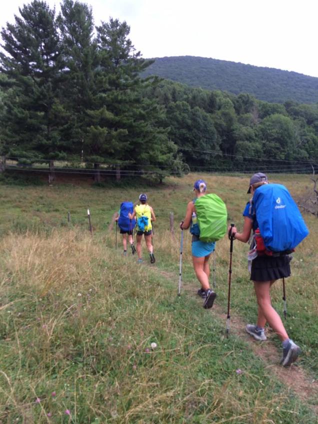
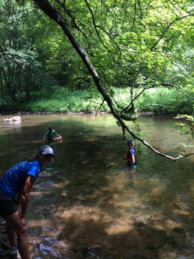
It became clear early in the day that we were not set up to “run” this fastpack. For starters, our packs, though light by backpacking standards, were way heavier than we were used to carrying. Secondly, even the most compact pack was a bit bouncy….a sure recipe for chafing later in the day. Still, we all had trekking poles, and with a brisk pace averaged a respectable 3 mph. With hours of daylight and (mostly) high spirits we enjoyed our ramble, taking the time to refill water at springs along the trail and soaking our sweaty bodies and tired legs in the Whitetop River.
By the time we rolled into the Lost Mountain Shelter at 3:30, spirits were lagging a bit. Heavy packs needed adjusting. Low blood sugar required a snack break. Rumbling thunder to the southwest made it easy to justify a 30 minute rest to refuel and take stock.
We knew we had about 5 hours of daylight, and 2.5-3 hours of hiking left. The thunder was right on schedule, and we decided if the storm hit we’d stay put and wait it out. However, after 20 minutes it was clear that the cell would stay to the south. As it faded off to the west we set out again, thankful that we had dodged the bullet. If our luck held, the clouds would clear out and we’d get our starry view after all.
Another hour passed, and a few more miles down the trail we crossed a road and I spotted the sign confirming that we had only three miles left. It was all uphill, so heads-down we started up….trying to wish away the gray clouds looming around us. As we entered the woods the sky darkened. The first rumbles of thunder announced the coming rain. It was clear that we were NOT going to skirt this cell. Nothing to do but move forward.
The rain started – gentle and cooling at first – then harder and fiercer. It came in bands…easing up ever so slightly before raging again. I’m not sure how long we were climbing…our pace slowed as the trail became an ankle-deep creek hiding the rocks. (Later estimates put the rainfall at 2-4 inches per hour!!) By the time we neared Buzzards Rock (~5500 ft. elevation), we were all COLD. Shivering in fact. The temperature had fallen to maybe 50 degrees, the wind was a full gale, and our bodies (clad in soaking wet running clothes) could not retain heat. We stopped and fumbled around for our rain gear….thank goodness we had all packed a waterproof shell!! It wasn’t comfortable, but it was a total lifesaver as we exited the tree cover and crossed over a mile and a half of exposed trail. The mountaintop was bald, and there was nothing to shield the 50 mph wind gusts.
It was a ghostly sight, all of us in a row…Sophie in the front disappearing into the fog, the rest of us single-file behind her. Most disturbing was the constant flash of lightning. There was nowhere to hide so we just moved forward as fast as we could. I sighed in relief, noting a spring that indicated we were close to the camping area. Finally, we crossed a Forest Service Road and over the Whitetop summit. As soon as we got into the trees, we’d be done!
Except we weren’t. It was clear as soon as we surveyed the camp sight that there was no way to escape the rain. I tried to set up my rain fly, but with its paltry footprint the ground remained a stream of mud and mulch. All five of us were rapidly becoming hypothermic, and there was simply no place to get dry. I suppose we could have huddled together under a few tarps, but two hours into the rain storm we had no idea how long we’d have to wait it out. If night fell and the temps dropped further, we’d be in serious trouble.
There were really only two realistic options – hike onward to the Thomas Knob Shlter seven miles down the trail, or call Jenny’s husband to come pick us up. We were already 10 hours into our day, hungry and tired. With the unexpected weather and proximity to the popular Grayson Highlands, there was a good chance that the shelter would be full by the time we arrived. Calling for a ride still required a five mile hike, but we were assured dry clothes and a hot meal. We opted for the sure thing and set out to meet Brock – our savior!!
As often happens in these situations, the driving, chilling rain continued for the next 45 minutes while we were hiking/running down the road. Brock was in the parking area by the time we arrived, and as soon as we’d changed into our dry gear and loaded up, the rain had stopped and the sun was peeking through. Hot pizza restored our morale and a good night’s sleep eased our tired bodies. What an epic adventure!
——————-
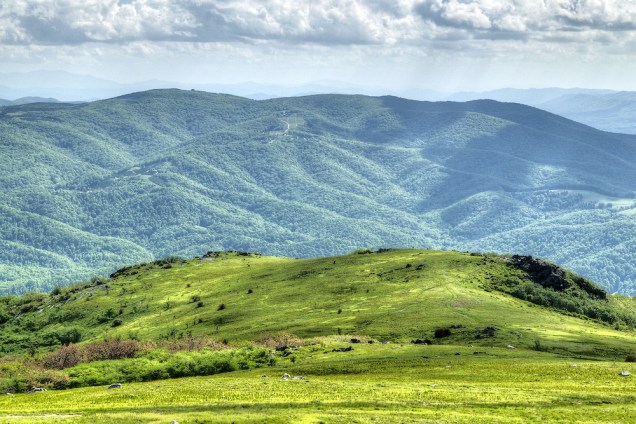
Sunday morning dawned cloudy and misty, so we slept in and then lingered over breakfast and coffee. Kate and Beth had family obligations, but Jenny, Sophie, and I returned to the trail. Starting at Massie Gap in Grayson Highland State Park (our original planned end point), we headed Southbound on the AT towards Mt. Rodgers. Though foggy, windy and cold when we started, as we climbed the sun emerged and we took in the fabulous views all around us. The park’s wild ponies were everywhere, chomping around for a bit of food and willing to pose for our pictures. It was a perfect end to our adventure…and an enticement to return in the near future.


———————
Takeaways
I’m on a bit of a high after this weekend. It’s been a long time since I’ve been HAPPY on the trail from start to finish. Even at my coldest and least comfortable, I was elated to be on the trail. There was such a comfort and security having everything I needed – clothes, food, shelter – on my back. Furthermore, the five of us were a TEAM. I love these women, but let’s be honest….when race bibs are pinned on we are racing each other to the line. It’s been awhile since I’ve had the opportunity to work together to reach a goal…and with hauling gear and dealing with unexpected weather we were stronger together than any of us would have been separately.
What worked well
- Our gear stayed dry. Some of us used rain flys, others lined their packs with a trash bag. But for the most part, everything that mattered stayed dry and warm despite the monsoon conditions.
- We planned for the weather. I can not emphasize enough how important our raincoats were and that they were accessible when we needed them.
- Similar fitness levels/team dynamic. Though paces varied throughout the day we spent little time waiting to regroup. Everyone could handle the mileage and through the day we were able to keep each other’s morale high.
- We had a plan & set realistic goals. While we all wanted to channel our inner Odyssa and Anish, we knew that 15-20 miles per day was good target for our first fastpack.
- We knew the area. Jenny, Beth and Kate knew the climbs, the road crossings, and where we’d have cell service. Again, for our first fastpack, this was gold.
- We had a bailout option. Never in a million years did i think we’d get hypothermic on a hot July day. But planning to camp at an accessible site with cell phone service saved our tails.
- Safety First. There will be times when the route or our appetite for adventure require us to dig deep and endure Mother Nature’s fury….but given our lack of experience and expertise, I believe we made the right call.
What could be improved
- Take advantage of shelters. To be honest, I didn’t give the weather enough respect. In trail running, bodies are moving fast enough and generating heat…generally that is enough to push through and get back to the cars. But when camping out there, the game changes. We could have sacrificed three hours of moving time and had a comfortable night at the shelter. In the future, I will plan to end each day at an AT shelter (when practical) or have a deeper skill set for extreme weather camping.
- Set up camp before weather hits. Again, if we’d stopped to set camp as soon as the clouds turned black, we would have more success riding out the storm.
- Know how to set up camp in extreme weather conditions. See above. Even if it means practicing in the backyard during a downpour, I plan to get the expertise to pitch a dry tent/hammock while fastpacking. We won’t always have an easy bailout option!
- Take a SPOT tracker. Just in case there isn’t cell service in the backcountry. All of us had concerned families at home, and for their sake its important that we be able to check in daily to let kids and partners know that we are OK.
- Monitor pack weight and comfort. Backcountry essentials add up, and its a constant struggle to balance comfort while moving with comfort in camp. Over the past year, I’ve made a point to replace worn out supplies with lighter weight options. As a result, my pack’s base weight (w/o food, fuel, and water) was a very manageable 13 pounds. Fully loaded with food and water it was a little under 20.

Resources/Notes:
- Since we didn’t spend the night on the trail, I’m going to hold off listing and reviewing the individual pieces of gear I used. The exception is the EXCELLENT Patagonia Torrent rain shell. Last year’s LUS prize, it totally saved my hide and kept my core warm.
- Meghan Hick’s article on Fastpacking at iRunFar.com was invaluable for researching and prepping this adventure. I was a total newbie, but had everything I needed on the trail. (http://www.irunfar.com/2014/12/the-definitive-guide-to-fastpacking.html)
- Unless otherwise noted, all images are credit Sophie Speidel, Copyright 2016.
